

Humminbird Helix 7 GPS G4 CHIRP MEGA SI Probe TA 140/240kHz

Rate: 4.3 - 6 votes
See reviews
For more than 40 years, Humminbird has been the benchmark in the world of underwater detection. This brand allows recreational and professional anglers to be even more efficient on the water, day after day and year after year.


Humminbird Helix 7 GPS G4 CHIRP MEGA SI Probe TA 140/240kHz
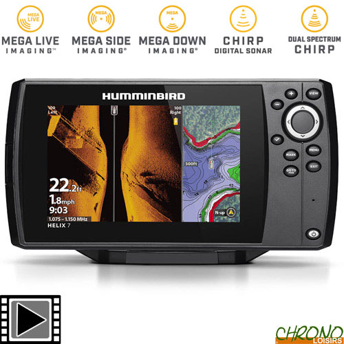
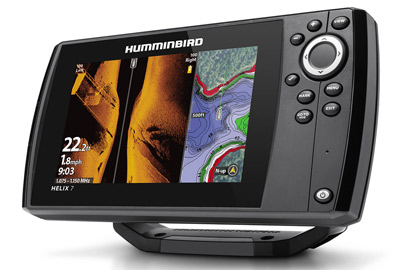
The HELIX 7 CHIRP MEGA SI GPS G4 fish finder features MEGA Side Imaging, MEGA Down Imaging, Dual Spectrum CHIRP Sonar, AutoChart Live, Internal GPS and Humminbird Basemap built-in. An upgraded high-definition 7" display will give you the best view of the many pre-loaded split screen view options so that you'll never miss a fish.
Maîtrisez votre HELIX par simple pression sur un bouton. Accédez aux vues préchargées à partir du système de menu convivial, commandé par des touches logicielles qui vous permettent d'utiliser votre sondeur de manière fiable dans toutes les conditions.
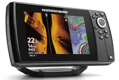
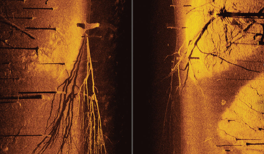
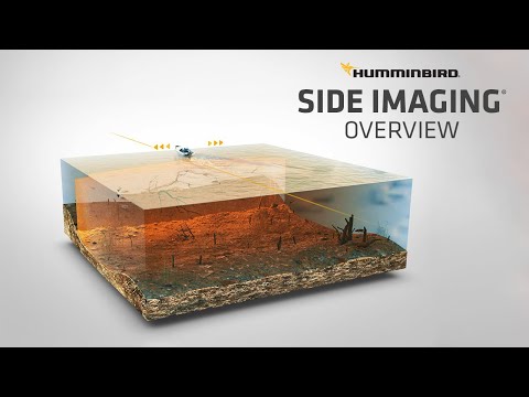
MEGA Side Imaging: See the world below like never before with crystal-clear viewing out to 125 feet on either side of your boat. You'll unlock new details with up to 3X more detail than standard Side Imaging sonar.
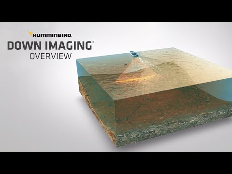
MEGA Down Imaging: Get unprecedented underwater clarity with coverage down to 125 feet below your boat. You'll unlock new details with up to 3X more detail than standard Down Imaging sonar.
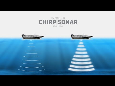
Dual Spectrum CHIRP sonar: Before you cast, know what's down there thanks to highly-detailed fish arches and a clear view of fish-holding structure and the bottom. Powered by our proprietary, Low-Q CHIRP transducer, Dual Spectrum CHIRP 2D sonar offers two ways to search; Wide Mode for maximum coverage and Narrow Mode for focusing on the slightest detail.
Internal GPS and Humminbird Basemap: Our enhanced basemap provides you with a clear view of underwater terrain and surrounding points of interest so you can fish and navigate with total confidence. Identify buoys, day markers, hazards, marinas, contours, depth markers and much, much more. Includes charts of more than 10,000 lakes, plus coastal coverage for the continental U.S.
Premium Chart Compatible: Humminbird provides the most complete offering of premium chart options to anglers everywhere. Get a complete view of the world below with optional charts from Humminbird's LakeMaster® and CoastMaster™ products, as well as your choice of compatible Navionics® charts.
AutoChart Live: Create real-time maps of your fishing spots, with access to patented Humminbird® LakeMaster® features. Map depth contours, bottom hardness and vegetation as you drive your boat. Comes standard with eight (8) hours of built-in recording time and is compatible with AutoChart Zero Line SD cards for virtually-endless AutoChart Live mapping capacity.
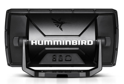
Includes control head, transom-mount transducer, power cable, gimbal mounting bracket and mounting hardware.
Technical specifications:
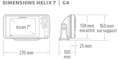
- 7" full sun colour display
- Screen type: TFT Colour
- Number of colours: 256
- Screen size W x H: 110 x 65 mm
- Power supply type: 10 - 20 VDC external
- Waterproofing IPx7
- Integrated GPS antenna
- Very high resolution screen: 1024x600
- Card reader : Yes
- Number of navigation screens: 2
- Number of Waypoints: 2500
- Number of points per track: 20000
- Number of routes: 45
- Number of tracks: 50
- Dual Spectrum CHIRP technology
- MEGA Down Imaging Technology
- MEGA Side Imaging Technology
- Sonar beams: 20°, 42°, 60° & (2) 86° @ -10dB
- CHIRP module frequencies: 83/200 (75-155/130-250 kHz), Full mode (150-220 kHz), Narrow mode (180-240 kHz), Wide mode (140-200 kHz)
- Sonar frequencies supported: 50/83/200/455/800 kHz
- Sonar depth: 365m (standard transducer)
- CHIRP Imaging-Supported frequencies: 455 kHz (420-520 kHz), 800 kHz (790-850 kHz)
- Depth-Down Imaging Imaging-Frequencies: 120m (455 kHz), 38m (800 kHz)
- Range-Side Imaging Imaging-Frequencies (Side-To-Side): 240m (455 kHz), 76m (800 kHz)
- Keyboard control
- Integrated GPS, Integrated Mapping, Dual Spectrum CHIRP, MEGA Down Imaging, MEGA Side Imaging
- Micro SD card slot
- Compatible with: AIS, Autopilot, Minn Kota US2 depth sounder
- Power consumption: 800mA
- Input: 10.8-20 VDC
- Power output (peak): 4000W
- RMS output power: 500W
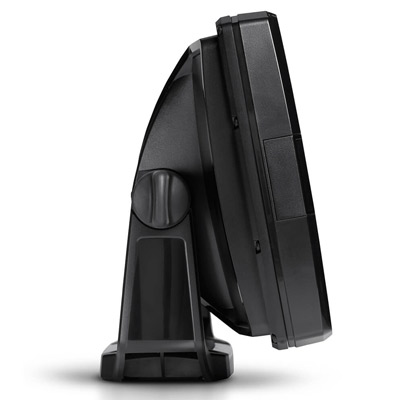
- Display mounting bracket included
- Compatible with LakeMaster, Coast Master, Navionics Gold/HotMaps, Navionics Platinum
Dimensions: 27cm x 16cm 10cm - Weight: 2.6kg
Fishfinder functions:
- Low battery alarm
- Temperature alarm
- Fish alarm
- Depth alarm
- Freeze frame
- Screenshots
- Giant numbers
- Customisable data
- Split screen with 2 frequencies
- RTS window
- Noise filters
- Fish ID
- Fish ID+
- ID Structure and Reverse
- Navionics Chartplotter
- Grey and white line
- X-Press menu
- Built-in simulator
- Water temperature
- Chart speed
- Optional surface speed
- Bottom speed
- Zoom on the bottom
GPS function:
- Arrival alarm
- Drift alarm
- Off course alarm
- Map reader
- Route projection line
- North map orientation
- Map orientation to destination
- Tracking device
- GPS speed
In the box:
- Handset display
- Display mounting bracket
- Transom probe
- Probe bracket
- 12Vdc power cord
- User manual
MEGA Imaging
MEGA Imaging® takes fish finding into the megahertz range for more detail and domination. Pioneered by Humminbird®, the clarity of MEGA Imaging can help you easily distinguish fish from structure, see the direction fish are facing and even target individual species. MEGA 360 Imaging® (in option) can see in more directions and delivers more clarity. And MEGA just got even better. With the introduction of MEGA Live Imaging™️ (in option), you can see fish in real-time, allowing you to learn what makes the fish want to bite.
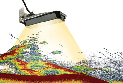
MEGA Side Imaging
Select MEGA Side Imaging® for an incredible view to both sides of your boat. Delivering up to 3X the output of standard Side Imaging®, MEGA Side Imaging technology took fish finding into the megahertz frequency for the very first time. And with MEGA Side Imaging+™, there’s absolutely no place left to hide, thanks to extended range out to 200 feet on either side, plus 20% more detail than MEGA Side Imaging.
MEGA Down Imaging:
Count on MEGA Down Imaging® for a crystal-clear picture below your boat. With up to 3X the output of standard Down Imaging®, MEGA Down Imaging shows you what lies beneath in crystal-clear detail. And with MEGA Down Imaging+™, fish don’t stand a chance, thanks to extended depth down to 200 feet, plus 20% more clarity than MEGA Down Imaging.

Dual Spectrum CHIRP Sonar
CHIRP stands for “Compressed High Intensity Radar Pulse.” That’s a fancy way of saying it can show you fish that other forms of 2D sonar can’t. How’s that? CHIRP scans the water for fish similar to the way the seek function on your truck’s radio scans the airwaves for FM stations. By covering a wide range of frequencies, CHIRP produces more accurate, more detailed returns of fish, structure and the bottom.
Product presentation
Products related to this item: